China is already considered one of the top two global powers, the other being the United States. Its GDP, at U.S.$7.3 trillion, is already the second largest and is poised to overtake the U.S. GDP, at U.S.$15.2 trillion, by 2020, as most estimates suggest.
China’s GDP is expected to grow at 7.8% in 2012, making it the
fastest growing major economy in the world. The Economist Intelligence Unit predicts that China’s real GDP growth is expected to average 7.9% a year in
2013-17.
China is the world’s largest exporter of finished goods (U.S.$1.9
trillion in 2011) and the second largest importer (U.S.$1.7 trillion in 2011).
It is the biggest consumer of energy resources and as its economy expands, its
energy hunger will only grow.
Almost all of China’s external trade is sea-borne; in fact, shipping
lanes are the life blood of China’s trade with the world. It is in the light of
this crucial fact that we can appreciate China’s Malacca Dilemma.
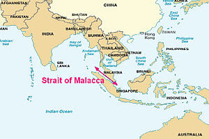
The Malacca Strait is a narrow channel of water that separates the
Malaysian Peninsula from the Indonesian island of Sumatra. In geographical
terminology, a strait is a narrow channel of water that separates two land
territories and connects two water bodies; for one, look at the Palk Strait
between India and Sri Lanka.
The Malacca Strait is one of the world’s busiest shipping lanes,
with over 85000 vessels passing through it every year. Located pretty close to
this is Singapore; an island City State, Singapore is separated from the
Malaysian peninsula by the Johor Strait.
Singapore hosts a huge naval base belonging to the United States
Navy. In fact, it is the U.S. Navy that more or less controls the Malacca
Strait and other water-based trade channels in this part of the world.
It is this reality that is giving Beijing the jitters because more
than 70% of China’s energy supplies move through the Malacca Strait.
 |
The External Boundaries of India as depicted
in these maps are neither right nor authentic.
|
China
has never concealed its ambitions to become a world hegemon though it often
mouths platitudes like ‘peaceful rise’. It wants to convert the Pacific Ocean
into a Chinese lake. Also, it is scouring different parts of the world for
sourcing raw materials and to sell finished goods.
China
treats the U.S. as the biggest obstacle to realize not just its ambitions of
turning the Pacific Ocean into a China lake but also become the second pole in
global power order. In fact, it is waging a massive low-intensity diplomatic
war with the U.S. for political and economic influence around the world at
large and in the Pacific in particular.
Today,
despite all the superficial U.S.-China bonhomie, there is a great deal of
mistrust (and distrust) between Beijing and Washington. Also, Beijing is
involved in a tug-of-war with almost all maritime nations in its neighborhood,
like Vietnam, Philippines, and Indonesia mainly on account of Beijing’s claims on
all of the South China Sea and the resources (like oil and gas) and islands
therein.
In
the light of these facts, China fears that if a war with the United States (or
with American allies, like Indonesia, Philippines and Vietnam) breaks out, the
latter will block access to the Malacca Strait.
Such
a development will stop the movement of vessels carrying energy resources (like
oil & gas) and raw materials to Beijing that are absolutely central to fuel
its humongous economy and waging a war.
This
would place China at the mercy of its rivals, which in turn may stoke social,
political and economic instability within the nation, all of which may come
together to threaten the very existence of the Communist Party of China.
To
avoid such an internal scenario, Beijing is trying very hard to bolster its external
defences not just to secure its economy but also the communist party’s future. To
resolve its Malacca Dilemma, Beijing has embarked on the ambitious Ring of
Pearls strategy. We will focus on that in the next installment of The
Explainer.

2 comments:
The lines "The External Boundaries of India as depicted in these maps are neither right nor authentic" are interesting.
After so long I am reading The explainer, good to see BJ with the Explainer
Post a Comment